17 days OR to Colorado and back
#1
 07-17-2014, 09:10 PM

Join Date: Apr 2014
Location: Oregon
Posts: 87
Likes: 0
Received 0 Likes
on
0 Posts
Robert asked for some trip reports. I'll give it a shot here.
I recently completed a 17 ride with my wife in the western and southwestern states. It was our first of hopefully many to come!
I'm going to update 4 days or so at a time. Here we go!
OR to Colorado and back – 17 days in June 2014
My wife and I just did this 4k mile trip. It was our first big trip together and it was fantastic!
I started planning this trip in March and tried to get my Road King in order… enough luggage space, reliability, convenience and comfort for the both of us. I took a 7 day solo trip last November so had an idea of what we needed such as bags, power for GPS, etc. I did a couple of mods on the bike (comfort seat, adjustable passenger footboards, power outlets, RAM mounts). After a couple of destination plan revisions, we had a great trip planned that takes us through Hwy 50 (the loneliest highway) near Tahoe, Las Vegas to see my uncle, Zion, Monument Valley, Albuquerque to see my old friends, Durango and Mesa Verde, Moab, etc. I know there are lots of great motorcycle roads around these areas so actually used HD Forums for great advice. Thanks all!
I’ll try to cut this version a little bit, but in the course of planning this trip of a lifetime, I decided to blog it daily as we rode and made a website for it at http://www.motoforever.com. Please comment and help me to make that one better and better. I love anything motorcycles and that includes that blog site now.
Here is the day 1-4 of my trip recap: Link for the Google map (I can't post a google map link here, but I'll put it on motoforever.com)

Day 1 of 17
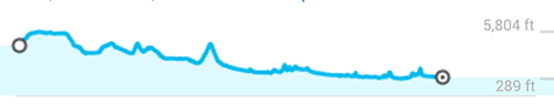
Eugene OR to Susanville, CA Via US 5, US 395, US 89, US 44, US 36 – 390 miles, Interstate, twisty and scenic
Elevation: 289 ft. to 5,804 ft.
I start in June from Oregon solo, but packing everything for two. My wife is going to meet up with me in Vegas where we are celebrating my uncles 83rd birthday. Linda is riding with me the rest of the trip. I’ve got the Harley Road King decked with Tour Pak, Saddlebags and rack bag. Plenty of room and we’ll be staying in motels along the way.
Leaving Oregon
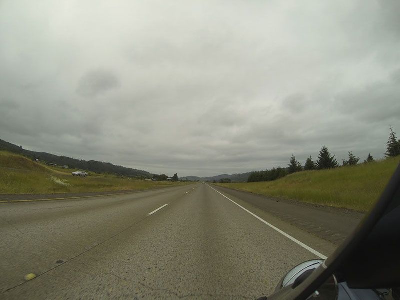
First stop Susanville, CA. The southern portion of I-5 through Oregon is a nice easy ride to start the trip. It has plenty of curves, mountain passes and beautiful tall trees. However, on this day, the road starts out cloudy, slightly damp and cold. I almost stopped a few times just to put on my cold gear, but I kept thinking positive thoughts to keep warm and hoping that the sun would come out and warm things up. If you know Oregon, you know this can happen in May pretty often, but in June it usually is consistently nice out. The temperature finally warms for me after 150 miles and the rest of the trip is clear sailing.
Past Shasta Mountain I head east toward Susanville on CA 89 through McCloud. This is a fun road with lots of curves and great views. So far, there’s nothing too technical, and there aren’t many straight interstates either. It’s a very nice first day.
Day 2 of 17
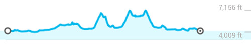
Susanville to Fernley, NV Via US 395, US 80, US 50, Alt 50, SR 341 – 245 miles, Interstate, twisty and scenic
Elevation: 3,895 fto. To 7,156 ft.
I actually did more riding on this day than I counted. This stretch goes right through Reno and then on to Carson City via Virginia City with excursions thru Lake Tahoe before ending up in Fernley, NV. So I officially start the Hwy 50 (the loneliest road in America) from Lake Tahoe and then on to Fernley.
The road from Susanville to Reno is similar to the day before and familiar to my Oregon areas. But after Reno, it starts getting fun. Geiger Grade (NV 341) south of Reno is a nice curvy jaunt to Virginia City. It is twisty, very curvy and fun to ride. Try to time it so there are no cars in front of you as you head up the hill. I had a corvette (that I caught up to) in front of me for about ˝ the ride up. They were having fun in their red convertible. It always amazes me how much faster motorcycles are than cars on turns. NV 341 will take you through Virginia City where you’ll see lots of bikes parked on the street. It’s a popular moto destination over that pass. I continue on down to Carson City and on to Lake Tahoe via US 50. Anytime you’re going over passes like this, and you have 2 lanes, you’ll find lots of bikes. So true with this one too. Bonus, when you get over the pass, you head down into Lake Tahoe and enjoy those beautiful views and nice cool air. I find a nice spot for lunch at Sams Place in Zephyr Cove, just outside of South Lake Tahoe.
Back to Hwy 50 and it’s eastbound for a long stretch. It’s dry desert time. I bought a hydration backpack at REI before I left and am making good use of it! It is very thin and light pack, and I am only using with fluids so is not bulky fitting at all. I find that I’ll start drinking 15 minutes into my ride and it really helps to keep me alert and feeling good. No alcohol… just the water… so I get my bearings on Hwy 50 and what it is all about. Desert… periodic towns and cross roads…lots of history… it reminds me of Route 66 in a way, but more historic. The history here is 1800s and turn of the century stuff. Cool.
I get to Fernley, NV with enough time to check out the town a bit.
Horse riders along the highway

Heading up Geiger Grade
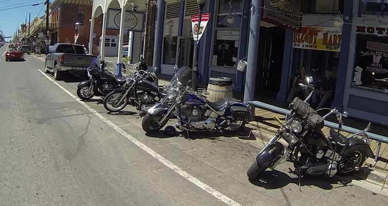
Bikers in Virginia City!
Day 3 of 17
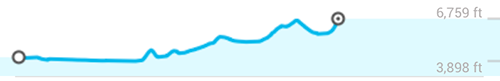
Fernley to Austin, NV Via US 50, SR 2, SR 722, Alt 50 (The Loneliest Road in America) – 210 miles, paved highway, curves and valleys
Elevation: 3,898 ft. to 6,759 ft.
I’m eastbound on the loneliest road in America. This is a land of extremes, its hot, dusty, the sand on the sides of the road is soft, there are long stretches where you won’t see anyone going past. I can only imagine what it was like living and growing up here. You are on your own, your wits, determination and you make your own way. You can count on one person out here and there are no pointing fingers. I meet and talk with people that grew up here. Nowadays, they’ll drive 100 miles to get to the grocery store. They love this area and it shows in the stories that I hear. It’s really nice to be able to take the time to talk with the local people. Hearing the stories is such a blast!
There is a really fantastic County Museum in Fallon, NV. If you have time, stop here. The people are wonderful and can show you around the exhibits, but they also have stories to tell of their life here over the years.
Taking pictures with my GoPro “button”
And make sure to stop at Tu Brothers motorcycle shop while in Fallon. These guys are very helpful and colorful and they do great things with bikes on Hwy 50.
My first emergency:
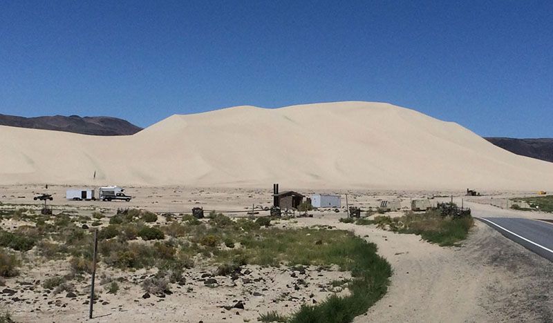
I turn off the road to see the Sand Mountain Recreation Area. I did my research and know there are speed dips to watch out for here. But, I forgot. Don’t you forget or… I hit the first one at 25 mph! They are really square edge (seems like) 3 foot deep cement channels cut in the road to accommodate water flooding. Whoa! I got airborne and after landing looked back at my bike and noticed that the Harley Tour Pak was leaning back! The mount was bent and luckily the locking quick release held the Tour Pak on and off my rear fender. You can’t ride it like that, so I turned into MacGyver and bent and reformed the mount until it would work. I’ve been riding bikes for over 35 years. How could this happen to me?! Glad to say, I had no issues with it until I was in Vegas to get a new mount put on, no scratches or permanent damage. OK, lesson learned. I am a long way from home, it’s a long way from service and it’s up to me to make it all the way.
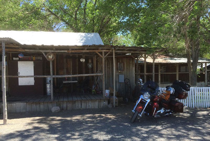
I stop for lunch at Middlegate Station. This place has great food and is run by very nice people. I enjoy my lunch outside where I meet a few bicycle riders going cross-country. Wow, what a challenge. They have really cool maps with elevation for all of the options to help them choose their paths. I like that…
OK, I’m feeling better now. I decide to take a side road on NV 722. A recommendation from a local. This takes me right past the Smith Creek Playa where this year’s International 14th Annual Landsailing World Championships are being held on July 12-19. Nice to see big things happening way out here.
I stayed the night in Austin, even though I arrived early. There are already bikers showing up from both directions. Many are just getting gas, but many are also staying the night. Bikers like to stay in Austin because there is gas, food and a few motels here. Those are all precious commodities on Hwy 50 in this area. Oh, and Austin is the home to the Navy’s Top Gun training grounds. There is a bombing practice range too. You rarely see the fighter jets, but you can hear their sonic booms! Reminds me of growing up when you would hear those booms on a near daily basis. The jets here fly below the hill-tops so its difficult to see them for very long.
I eat with a couple of long riding bikers and we have a great time talking about motors, bikes and enjoying the open roads.
Some of the side roads are nice
Sand Mountain Recreation Area
Middlegate Station for eats
Day 4 of 17
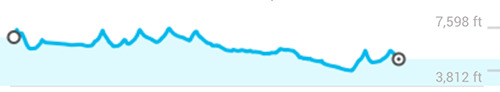
Austin to Rachel, NV Via US 50, SR 318, SR 375 – 320 miles, Paved Hwy with curves, mountain passes, long straights.
Elevation: 3,812 ft. to 7,598 ft.
I continue east on 50 to Eureka. I can tell this town was a big deal back in the day. They have an opera house placed prominently in town as if to say “we are important!” Eureka is the county seat and the largest town in the area. There are many old buildings here (1870s) with some that are still in use! There is a self guided tour on their website with lots of great info.
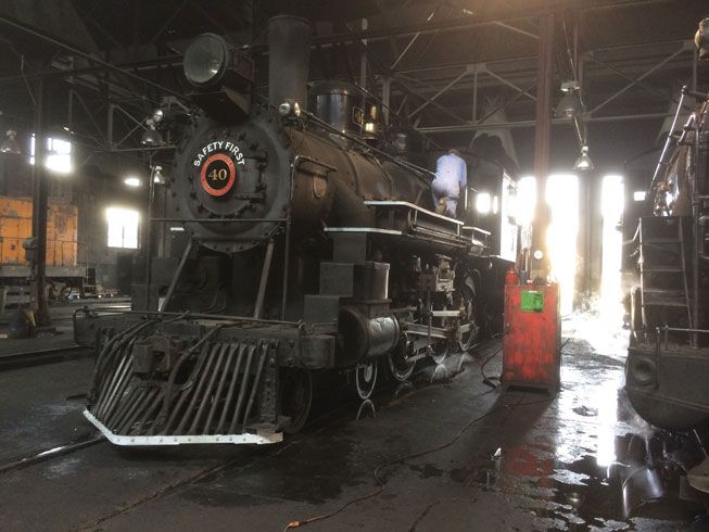
I’m on my way toward Ely, NV before I head south for Las Vegas. I am told to go to the train museum in Ely. It’s 100 miles from Eureka so there is plenty of time left for sightseeing along the way. Go all the way through Ely to find the train museum and you won’t be disappointed. It really is a fantastic railroad museum. They have working trains that they take out daily that you can ride in. They are fully in-service running trains. I am there while they pull out the huge wrecking car using their 1930s diesel electric engine. Wow, the sound of the booming engines and torque puts my Harley 110 to shame! That’s power! Can you imagine the equipment it takes to lift a train that has run off the track? That’s a wrecker car. You can’t have a railroad without one nearby. My grandfather was a mechanic for the Southern Pacific near Needles CA. This place is especially nice for me to see familiar trains and actually get to walk throughout the actual working mechanics areas. As a visitor you sign your life and everyone’s responsibility away in return for full access in and around this working museum. You get full access right up to the moving trains, near the work pits, and around the huge mechanical tools and presses. Just another reminder to use your head every now and then… I loved it.
Ely Train Museum has working trains
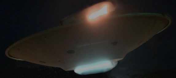
After Ely (pronounced eee-lee) I head south to Rachel, NV, which is sort of on my way to Vegas. Rachel is the town 40 miles up the Extraterrestrial Highway (NV 375) known for its proximity to Area 51. There are a couple of hills to cross and with it a couple of curvy sections. This highway has many tar snakes so watch out if the sun has been baking it all day. There are also some of the most boring straights that I’ve been on so far this trip. The locals warn me of patrol cars giving speeding tickets lately so I try to keep the speeds down. I stay at the Little A’Le’Inn motel. I pay in cash… They were making a film about saucers and other unusual things when I was there. Cool. Rachel is 150 miles from Las Vegas so a quick jaunt in the morning will get me to my uncle’s house in time for lunch. I went to Area 51 looking for flying saucers in the night, but I should have been looking for aliens! Why would E.T. show you their flying saucer, after all?
Flying saucer in Rachel, NV
I’ll start recapping day 5-8 next.
Read the entire trip at http://www.motoforever.com
Thanks for reading!
Rod and Linda
I recently completed a 17 ride with my wife in the western and southwestern states. It was our first of hopefully many to come!
I'm going to update 4 days or so at a time. Here we go!
OR to Colorado and back – 17 days in June 2014
My wife and I just did this 4k mile trip. It was our first big trip together and it was fantastic!
I started planning this trip in March and tried to get my Road King in order… enough luggage space, reliability, convenience and comfort for the both of us. I took a 7 day solo trip last November so had an idea of what we needed such as bags, power for GPS, etc. I did a couple of mods on the bike (comfort seat, adjustable passenger footboards, power outlets, RAM mounts). After a couple of destination plan revisions, we had a great trip planned that takes us through Hwy 50 (the loneliest highway) near Tahoe, Las Vegas to see my uncle, Zion, Monument Valley, Albuquerque to see my old friends, Durango and Mesa Verde, Moab, etc. I know there are lots of great motorcycle roads around these areas so actually used HD Forums for great advice. Thanks all!
I’ll try to cut this version a little bit, but in the course of planning this trip of a lifetime, I decided to blog it daily as we rode and made a website for it at http://www.motoforever.com. Please comment and help me to make that one better and better. I love anything motorcycles and that includes that blog site now.
Here is the day 1-4 of my trip recap: Link for the Google map (I can't post a google map link here, but I'll put it on motoforever.com)

Day 1 of 17
Eugene OR to Susanville, CA Via US 5, US 395, US 89, US 44, US 36 – 390 miles, Interstate, twisty and scenic
Elevation: 289 ft. to 5,804 ft.

I start in June from Oregon solo, but packing everything for two. My wife is going to meet up with me in Vegas where we are celebrating my uncles 83rd birthday. Linda is riding with me the rest of the trip. I’ve got the Harley Road King decked with Tour Pak, Saddlebags and rack bag. Plenty of room and we’ll be staying in motels along the way.
Leaving Oregon

First stop Susanville, CA. The southern portion of I-5 through Oregon is a nice easy ride to start the trip. It has plenty of curves, mountain passes and beautiful tall trees. However, on this day, the road starts out cloudy, slightly damp and cold. I almost stopped a few times just to put on my cold gear, but I kept thinking positive thoughts to keep warm and hoping that the sun would come out and warm things up. If you know Oregon, you know this can happen in May pretty often, but in June it usually is consistently nice out. The temperature finally warms for me after 150 miles and the rest of the trip is clear sailing.
Past Shasta Mountain I head east toward Susanville on CA 89 through McCloud. This is a fun road with lots of curves and great views. So far, there’s nothing too technical, and there aren’t many straight interstates either. It’s a very nice first day.
Day 2 of 17
Susanville to Fernley, NV Via US 395, US 80, US 50, Alt 50, SR 341 – 245 miles, Interstate, twisty and scenic
Elevation: 3,895 fto. To 7,156 ft.

I actually did more riding on this day than I counted. This stretch goes right through Reno and then on to Carson City via Virginia City with excursions thru Lake Tahoe before ending up in Fernley, NV. So I officially start the Hwy 50 (the loneliest road in America) from Lake Tahoe and then on to Fernley.
The road from Susanville to Reno is similar to the day before and familiar to my Oregon areas. But after Reno, it starts getting fun. Geiger Grade (NV 341) south of Reno is a nice curvy jaunt to Virginia City. It is twisty, very curvy and fun to ride. Try to time it so there are no cars in front of you as you head up the hill. I had a corvette (that I caught up to) in front of me for about ˝ the ride up. They were having fun in their red convertible. It always amazes me how much faster motorcycles are than cars on turns. NV 341 will take you through Virginia City where you’ll see lots of bikes parked on the street. It’s a popular moto destination over that pass. I continue on down to Carson City and on to Lake Tahoe via US 50. Anytime you’re going over passes like this, and you have 2 lanes, you’ll find lots of bikes. So true with this one too. Bonus, when you get over the pass, you head down into Lake Tahoe and enjoy those beautiful views and nice cool air. I find a nice spot for lunch at Sams Place in Zephyr Cove, just outside of South Lake Tahoe.
Back to Hwy 50 and it’s eastbound for a long stretch. It’s dry desert time. I bought a hydration backpack at REI before I left and am making good use of it! It is very thin and light pack, and I am only using with fluids so is not bulky fitting at all. I find that I’ll start drinking 15 minutes into my ride and it really helps to keep me alert and feeling good. No alcohol… just the water… so I get my bearings on Hwy 50 and what it is all about. Desert… periodic towns and cross roads…lots of history… it reminds me of Route 66 in a way, but more historic. The history here is 1800s and turn of the century stuff. Cool.
I get to Fernley, NV with enough time to check out the town a bit.
Horse riders along the highway

Heading up Geiger Grade

Bikers in Virginia City!

Day 3 of 17
Fernley to Austin, NV Via US 50, SR 2, SR 722, Alt 50 (The Loneliest Road in America) – 210 miles, paved highway, curves and valleys
Elevation: 3,898 ft. to 6,759 ft.

I’m eastbound on the loneliest road in America. This is a land of extremes, its hot, dusty, the sand on the sides of the road is soft, there are long stretches where you won’t see anyone going past. I can only imagine what it was like living and growing up here. You are on your own, your wits, determination and you make your own way. You can count on one person out here and there are no pointing fingers. I meet and talk with people that grew up here. Nowadays, they’ll drive 100 miles to get to the grocery store. They love this area and it shows in the stories that I hear. It’s really nice to be able to take the time to talk with the local people. Hearing the stories is such a blast!
There is a really fantastic County Museum in Fallon, NV. If you have time, stop here. The people are wonderful and can show you around the exhibits, but they also have stories to tell of their life here over the years.
Taking pictures with my GoPro “button”

And make sure to stop at Tu Brothers motorcycle shop while in Fallon. These guys are very helpful and colorful and they do great things with bikes on Hwy 50.
My first emergency:
I turn off the road to see the Sand Mountain Recreation Area. I did my research and know there are speed dips to watch out for here. But, I forgot. Don’t you forget or… I hit the first one at 25 mph! They are really square edge (seems like) 3 foot deep cement channels cut in the road to accommodate water flooding. Whoa! I got airborne and after landing looked back at my bike and noticed that the Harley Tour Pak was leaning back! The mount was bent and luckily the locking quick release held the Tour Pak on and off my rear fender. You can’t ride it like that, so I turned into MacGyver and bent and reformed the mount until it would work. I’ve been riding bikes for over 35 years. How could this happen to me?! Glad to say, I had no issues with it until I was in Vegas to get a new mount put on, no scratches or permanent damage. OK, lesson learned. I am a long way from home, it’s a long way from service and it’s up to me to make it all the way.
I stop for lunch at Middlegate Station. This place has great food and is run by very nice people. I enjoy my lunch outside where I meet a few bicycle riders going cross-country. Wow, what a challenge. They have really cool maps with elevation for all of the options to help them choose their paths. I like that…
OK, I’m feeling better now. I decide to take a side road on NV 722. A recommendation from a local. This takes me right past the Smith Creek Playa where this year’s International 14th Annual Landsailing World Championships are being held on July 12-19. Nice to see big things happening way out here.
I stayed the night in Austin, even though I arrived early. There are already bikers showing up from both directions. Many are just getting gas, but many are also staying the night. Bikers like to stay in Austin because there is gas, food and a few motels here. Those are all precious commodities on Hwy 50 in this area. Oh, and Austin is the home to the Navy’s Top Gun training grounds. There is a bombing practice range too. You rarely see the fighter jets, but you can hear their sonic booms! Reminds me of growing up when you would hear those booms on a near daily basis. The jets here fly below the hill-tops so its difficult to see them for very long.
I eat with a couple of long riding bikers and we have a great time talking about motors, bikes and enjoying the open roads.
Some of the side roads are nice

Sand Mountain Recreation Area

Middlegate Station for eats

Day 4 of 17
Austin to Rachel, NV Via US 50, SR 318, SR 375 – 320 miles, Paved Hwy with curves, mountain passes, long straights.
Elevation: 3,812 ft. to 7,598 ft.

I continue east on 50 to Eureka. I can tell this town was a big deal back in the day. They have an opera house placed prominently in town as if to say “we are important!” Eureka is the county seat and the largest town in the area. There are many old buildings here (1870s) with some that are still in use! There is a self guided tour on their website with lots of great info.
I’m on my way toward Ely, NV before I head south for Las Vegas. I am told to go to the train museum in Ely. It’s 100 miles from Eureka so there is plenty of time left for sightseeing along the way. Go all the way through Ely to find the train museum and you won’t be disappointed. It really is a fantastic railroad museum. They have working trains that they take out daily that you can ride in. They are fully in-service running trains. I am there while they pull out the huge wrecking car using their 1930s diesel electric engine. Wow, the sound of the booming engines and torque puts my Harley 110 to shame! That’s power! Can you imagine the equipment it takes to lift a train that has run off the track? That’s a wrecker car. You can’t have a railroad without one nearby. My grandfather was a mechanic for the Southern Pacific near Needles CA. This place is especially nice for me to see familiar trains and actually get to walk throughout the actual working mechanics areas. As a visitor you sign your life and everyone’s responsibility away in return for full access in and around this working museum. You get full access right up to the moving trains, near the work pits, and around the huge mechanical tools and presses. Just another reminder to use your head every now and then… I loved it.
Ely Train Museum has working trains

After Ely (pronounced eee-lee) I head south to Rachel, NV, which is sort of on my way to Vegas. Rachel is the town 40 miles up the Extraterrestrial Highway (NV 375) known for its proximity to Area 51. There are a couple of hills to cross and with it a couple of curvy sections. This highway has many tar snakes so watch out if the sun has been baking it all day. There are also some of the most boring straights that I’ve been on so far this trip. The locals warn me of patrol cars giving speeding tickets lately so I try to keep the speeds down. I stay at the Little A’Le’Inn motel. I pay in cash… They were making a film about saucers and other unusual things when I was there. Cool. Rachel is 150 miles from Las Vegas so a quick jaunt in the morning will get me to my uncle’s house in time for lunch. I went to Area 51 looking for flying saucers in the night, but I should have been looking for aliens! Why would E.T. show you their flying saucer, after all?
Flying saucer in Rachel, NV

I’ll start recapping day 5-8 next.
Read the entire trip at http://www.motoforever.com
Thanks for reading!
Rod and Linda
#3
07-17-2014, 11:02 PM
Join Date: Apr 2014
Location: Oregon
Posts: 87
Likes: 0
Received 0 Likes
on
0 Posts
#4
07-17-2014, 11:03 PM
Join Date: Apr 2014
Location: Oregon
Posts: 87
Likes: 0
Received 0 Likes
on
0 Posts
#5
07-18-2014, 08:24 AM
#6
07-18-2014, 12:02 PM
Join Date: Apr 2014
Location: Oregon
Posts: 87
Likes: 0
Received 0 Likes
on
0 Posts
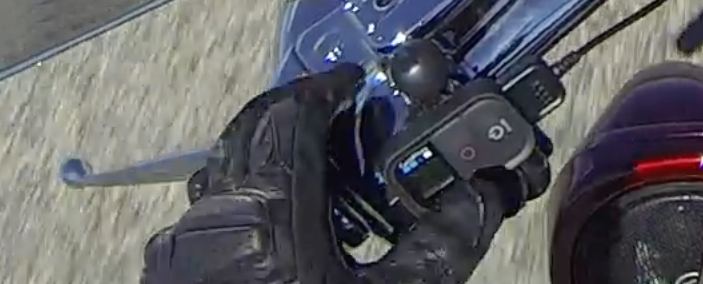
I am using a Powerlet plug on my handlebar. I also have a setup for my wife to use as a passenger. The GoPro wireless remotes battery gives out way before the camera does... and you can't simply replace the battery, it needs to be recharged before it can be used. So I just keep it attached to the USB charger and no problem.
Here is the full GoPro wireless remote plugged into the adapter

The Powerlet handlebar adapter with dual high power output USB

Rear GoPro mounted on passenger handrails

The Rear USB adapter mounted to the Tour Pak mount, it uses the Harley Y connector under the seat

As you can see, I've got power to spare. Some of the power comes direct from battery and some from Aux (switched) and some from front aux lights (which I don't have).
#7
07-18-2014, 12:08 PM
Join Date: Apr 2014
Location: Oregon
Posts: 87
Likes: 0
Received 0 Likes
on
0 Posts
Rod
Trending Topics
#8
07-18-2014, 01:22 PM
Thanks Robert,
I am using a Powerlet plug on my handlebar. I also have a setup for my wife to use as a passenger. The GoPro wireless remotes battery gives out way before the camera does... and you can't simply replace the battery, it needs to be recharged before it can be used. So I just keep it attached to the USB charger and no problem.
I am using a Powerlet plug on my handlebar. I also have a setup for my wife to use as a passenger. The GoPro wireless remotes battery gives out way before the camera does... and you can't simply replace the battery, it needs to be recharged before it can be used. So I just keep it attached to the USB charger and no problem.
One more question. How do you make the elevation graphs for your routes? Thanks again.
#9
07-18-2014, 03:00 PM
Join Date: Apr 2014
Location: Oregon
Posts: 87
Likes: 0
Received 0 Likes
on
0 Posts
Thanks for the explanation. I noticed on my last trip that the remote battery drains well before the camera battery. I have 4 camera batteries that I keep charged, so that's not a problem. I'll plug the remote into the power outlet on my Limited so it will work the whole day.
One more question. How do you make the elevation graphs for your routes? Thanks again.
One more question. How do you make the elevation graphs for your routes? Thanks again.
#10
07-18-2014, 03:23 PM
Google maps allows you to click route by bicycle. Not all roads are allowed for bikes so that can be a problem, but it gives the elevation map for bicycles. I learned that from one of the cross country bicycle guys on the trip and thought that would be most relevant for us bikers too!

